VISITAR
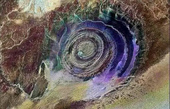
The Richat Structure, also called Guelb er Richât (Arabic: قلب الريشات, romanized: Qalb ar-Rīšāt), is a prominent circular geological feature in the Sahara's Adrar Plateau, near Ouadane, west–central Mauritania, Northwest Africa. In the local dialect, Richat means feather and it also is known locally in Arabic as tagense. Tagense refers to the circular opening of the leather pouch used to draw water from local wells.[1]
It is an eroded geological dome, 40 kilometres (25 mi) in diameter, exposing sedimentary rock in layers which appear as concentric rings. Igneous rock is exposed inside and there are spectacular rhyolites and gabbros which have undergone hydrothermal alteration, and a central megabreccia. The structure is also the location of exceptional accumulations of Acheulean archaeological artifacts. It was selected as one of the first 100 geological heritage sites identified by the International Union of Geological Sciences (IUGS) to be of the highest scientific value.
The Richat Structure is the location of exceptional accumulations of Acheulean artifacts. These Acheulean archaeological sites are located along wadis that occupy outermost annular depression of this structure. Pre-Acheulean stone tools also have been found in the same areas. These sites are associated with rubbly, outcrops of quartzite that provided the raw material needed for the manufacture of these artifacts. The most important Acheulean sites and their associated outcrops are found along the north-west of the outer ring, from which Wadi Akerdil heads east and Wadi Bamouere to the west. Sparse and widely scattered Neolithic spear points and other artifacts have also been found. However, since these sites were first discovered by Theodore Monod in 1974,[15] mapping of artifacts within the area of the Richat Structure have found them to be generally absent in its innermost depressions. So far, neither recognizable midden deposits nor manmade structures have been recognized and reported from the Richat Structure. This is interpreted as indicating that area of the Richat Structure was used for only short-term hunting and stone tool manufacturing. The local, apparent wealth of surface artifacts is the result of the concentration and mixing by deflation over multiple glacial-interglacial cycles.[16][17]
Artifacts are found, typically redeposited, deflated, or both, in Late Pleistocene to early Holocene gravelly mud, muddy gravel, clayey sand, and silty sand. These sediments are often cemented into either concretionary masses or beds by calcrete. Ridges typically consist of deeply weathered bedrock representing truncated Cenozoic paleosols that formed under tropical environments. The Pleistocene to Middle Holocene sediments occur along wadis as thin, meter- to less-than-meter-thick accumulations in the interior annular depressions to 3–4-meter-thick (10–13 ft) accumulations along the wadis in the outermost annular depression of the Richat Structure. The gravelly deposits consist of mixture of slope scree, debris flow, and fluviatile or even torrential flow deposits. The finer grained, sandy deposits consist of eolian and playa lake deposits. The latter contain well-preserved freshwater fossils. Numerous concordant radiocarbon dates indicate that the bulk of these sediments accumulated between 15,000 and 8,000 BP during the African humid period. These deposits lie directly upon deeply eroded and weathered bedrock.
Comentarios
Publicar un comentario